AbramClark
Active Member
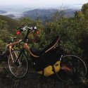
Just got back from one of my favorite rides in the Bay Area, from SF, over GG bridge, climbing 2900 feet up Mt Tamalpais, highest point in Marin county, then flying back down. Totaling 56 miles, leisurely ~5.5 hours. I'm Pretty happy with this Quest picture I snapped on the top of the ridge:

And here's another view of SF, with the Pacific (when doing a long climb so I'm getting hot and not riding fast, I like taking my shoes off), and a shameless selfie:


On a side note, yesterday I noticed my front disc brake was starting to rub, and something was floppy in the front. Turns out the axle nuts had worked themselves loose with the torque of the geared front hub. Watch out for this if you have a Quest!

And here's another view of SF, with the Pacific (when doing a long climb so I'm getting hot and not riding fast, I like taking my shoes off), and a shameless selfie:


On a side note, yesterday I noticed my front disc brake was starting to rub, and something was floppy in the front. Turns out the axle nuts had worked themselves loose with the torque of the geared front hub. Watch out for this if you have a Quest!


